Home to the Alps, which includes some of the highest peaks in Europe, as well as the Jura Mountains, Switzerland is an ideal mapping location for those students who enjoy hiking and/or are looking for somewhere with a more moderate climate. Most areas are generally well exposed and particularly good for those who are interested in mapping slightly more complex structural elements. The geology of Switzerland tends to be predominantly sedimentary rocks or meta-sediments, including the Tethys Ocean molasse of the Central Plateau, so there is often also opportunity to identify a variety of sedimentary structures in the field.
East Taschalp, Near Zermatt, Switzerland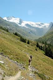
Outline of Geology: Greenschist metasediments, tectonically emplaced on eclogite ophiolite; whole area backfolded and messed up. Rock types distinctive, but hard to identify, lots of very cool, but weird minerals
Topographic description: 2200 - 3200m elevation, steep mountainous terrain. Exposure is excellent. Accommodation: Camped in valley, permission needed from council. Food: Restaurant in Tasch village: 20 mins by car, 2.5 - 4 hrs on foot. Transport: Travelled to area, and to shops by Car, within area on foot. Weather: Sunny most days, rained 2-3 times, little wind, glaciers above 3000m, temperatures about -2 - 27 C. Total cost: about £600: £210 travel; £350 food etc. Year Mapped: 1998 |
Col du Sanetsch, Near Gsteig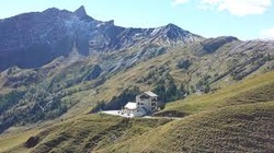
Outline of Geology: Limestone, with some structure - both folds and faults. One outcrop of sandstone.
Topographic description: 2000 - 2600m elevation, steep terrain. Exposure is excellent. Accommodation: Camped near stream. Food: Shop in Gsteig village: 4 miles (descent of 1000m) Transport: Travelled to area by car, to shops and within area on foot. Weather: Sunny most days, 1 week (mist is a problem, 1 day of wind, temperatures about -5 - 30 C. Total cost: about £400: £120 travel; £250 food etc. Year Mapped: 1999 |
Anzeinde and Les Diablerets
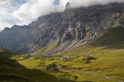
Outline of Geology: Jurassic and Cretaceous carbonate sequence shallowing upwards to emergence in late cretaceous. Extremely varied unconformity sediments deposited on submergence, emergence again followed by continued deepening. Flysch and turbidite deposition followed by thrusting and fairly extensive deformation, polyphase deformation features caused by back thrusting and back folding.
Topographic description: 1400 - 3000m elevation, extremely steep terrain, with many cliffs. Exposure variable, typically excellent.
Accommodation: Refuge Giacomini. Worked at weekends to keep costs down. £27 per day.
Food: Provided by hotel
Transport: Travelled to area by plane, train, tram, bus and foot and within area on foot.
Weather: Variable most days, mist and fog quick to onset, 1 day of wind, 1 week at start of snow and ice, temperatures about -6 - 28 C.
Total cost: about £400: £250 travel; £80 accommodation and food, Insurance: £70.
Year Mapped: 1993
|
Copyright © 2020 Oxford University Geological Society
|
