With the Iberian Plate squeezed between the Eurasian Plate to the north and the African Plate to the south, it's no wonder that Spain, shaped significantly by the Variscan and Alpine orogenies, has a fascinating and complex geological history which many undergraduates have loved reconstructing during their mapping projects. From Palaeozoic ophiolites, to Quaternary sedimentary basins and volcanics, there is so much variety in the geology across Spain (including it's surrounding islands) that we even get to go to Almería, Southern Spain, for our 3rd year field trip! Particularly popular areas include the Cantabrian Mountains along the Northern coast of Spain, as well as the Pyrenees and Ebro Basin further east and the Baetic Mountains found along Spain's southern coast. It can get really hot mapping in Spain, so make sure to pack plenty of sunscreen!
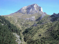
Aguero, Gallego Gorge, Western External Sierras, The Pyrenees Mountains
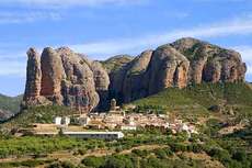
Outline of Geology: Thrust front of Pyrenees, major recumbent anticline is possible to map, and two backthrust packages.
Topographic description: 500 - 1200m elevation, steep, rugged mountainous terrain with gorges. Exposure good, but access can be difficult.
|
Year Mapped: 1998
Accommodation: Hotels and in a disused church cost £5 - 8 per day. Food: In local shop in village 200m away. Transport: A car was used to get to and around the area. Walked to the shops. Weather: Lots sunshine every day, 3-4 days in all, no wind, snow or ice, temperatures about 85 - 90 F. Total cost: about £1120: £600 travel; £320 accommodation, £200 food. Vertical Divider
|
Year Mapped: 2000
Accommodation: Hostel in Azanigo (£4 per day) and Campsite in Aguero (free on special deal) Food: Agerbe 40km from Azanigo, 13km from Aguero Transport: Used a car for getting to and travelling within area, also for the shops. Weather: lots of Sunshine, little rain, a few storms, some wind, no snow or ice, temperatures about 25 - 35 C. Total cost: about £900: £480 travel; £150 accommodation, £? food; £230 Insurance. |
North West Mallorca, Balearic Islands
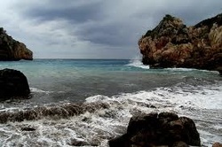
Outline of Geology: Dominantly carbonate thrust sequence, little folding. Sandstones and marls, platform carbonates, calcareous turbidites. Only very isolated igneous outcrops of altered basalts. No metamorphic rocks.
Topographic description: 0 - 930m elevation, mountainous terrain, cliff coastline rugged topography. Exposure excellent outside of settled areas.
Accommodation: Private villa in Solle. Cost £8.50 per day.
Food: In local shop 100m away and supermarket 2 miles away.
Transport: Plane and a car was used to get to and around the area. Walked to the shops.
Weather: Lots sunshine every day, 1 day of rain and 12 minute downpour, slight breeze, no snow or ice, temperature averaged about 35 C.
Total cost: about £820: £300 travel; £400 accommodation, £120 food.
Year Mapped: 2001
Cantabrian Mountains, North-West Spain
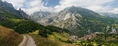
Note: There are 5 distinct project areas all located within 60km of the Esla Valley: Esla Valley, Villamanin, Cervera de Pisuerga, Celada de Roblecedo, Los Barrios de Luna.
Years Mapped: 1992, 1993, 1995, 1997, 1999, 2000, 2001, 2002, 2003.
Outline of Geology: Sedimentary sequence, Cambrian to Carboniferous. Extensive thrust faulting. Local igneous bodies.
Topographic description: 1100 - 1900m elevation, steep, mountainous terrain. Exposure variable between areas.
Years Mapped: 1992, 1993, 1995, 1997, 1999, 2000, 2001, 2002, 2003.
Outline of Geology: Sedimentary sequence, Cambrian to Carboniferous. Extensive thrust faulting. Local igneous bodies.
Topographic description: 1100 - 1900m elevation, steep, mountainous terrain. Exposure variable between areas.
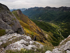
Esla Valley, Cantabrian Mountains
Exposure: Good - Brilliant! Years Mapped: 1993, 1995, 1999, 2001, 2003 |
|
|
Year Mapped: 2001
Accommodation: Cistierna campsite cost about £2.50 per day. Food: Local supermarket 5mins walk. Transport: Used a car for getting to area and travelling within area. Walked to the shops. Weather: A lot of hot sunshine, rained for 5/6 days, occasional light breeze in hills, no snow or ice, temperatures ranged from -4 - 40 C Total cost: £520 : £200 travel; £120 accommodation; £200 food. Vertical Divider
|
Year Mapped: 1999
Accommodation: Campsite about £3 per day. Food: Supermarket 300m away. Transport: Used a car for getting to area, travelled within area and to the shops on foot. Weather: Loads of sunshine, not much rain, no wind, snow or ice, temperatures about 32 - 35 C Total cost: £450 : £230 travel; £120 accommodation; £90 food. |
|
Year Mapped: 1995
Accommodation: Camped by river on rough ground Food: Village shop about 500m away, hypermarket 1.5 hour drive. Transport: Used a ferry to Santander, Train to Cestierna and a bike for getting to area, travelled within area and to the shops on bike or by foot. Weather: Sunny constantly until September when it rained. not windy, a frost on one morning, temperatures up to about 27 C Total cost: £350 : £150 travel; £0 accommodation; £200 food. Vertical Divider
|
Year Mapped: 1993
Accommodation: Camped by river on rough ground Food: Village shop about 500m away. Transport: Used a ferry to Santander and a bike for getting to area, travelled within area and to the shops on bike. Weather: Sunny constantly, rained for a week in fierce thunderstorms, occasional light breeze, one hailstorm, temperatures up to about 35 C Total cost: £600 : £80 travel; £0 accommodation; £500 food. |
Villamanin, Cantabrian Mountains
|
Exposures: Depends on rock, good - poor
Year Mapped: 2002 Accommodation: Group I: Bosque De Gordon Campsite (La Pola De Gordon) - Cabins about £30 per day. Group II: Locally Owned Apartments about £300 for 6 weeks. Food: Supermarket a few minutes walk. Transport: Group I: Flight to Madrid, Train to Pola De Gordon. Walked and cycled within area. Group II: Flight to Madrid, Bus to Leon, Bus to Villamanin. Walked and Cycled within area. Weather: Sunny and hot most days, rained once in 6 weeks, little wind, no snow, temperatures 7 - 40 C. Total cost: Group I: £1700: £140 travel, £1400 accommodation, £140 food. Group II: £700: £140 travel, £300 accommodation, £150 food. |
|
|
Year Mapped: 2001
Accommodation: Bar Nagasaky, Villamanin, Private Appartment. and Hostel Esequiel. Food: Supermarket in village Transport: Used a car for getting to area, travelled within area and to the shops on foot. Weather: Sunny for 6 weeks, rained for a few days in heavy thunderstorms, occaisional light breeze, no snow or ice, temperatures up to about 45 C Total cost: £750 : £300 travel; £250 accommodation; £200 food. Vertical Divider
|
Year Mapped: 1999
Accommodation: Bar Nagasaky, Villamanin, Private Appartment. Food: Supermarket in village, hypermarket in Leon. Transport: Used a car for getting to area and to go to the shops, travelled within area on foot. Weather: Sunny for 5 weeks, rained for 2 weeks, but storms frequent at night, occaisional light breeze, no snow or ice, temperatures up to about 36 C Total cost: £1350 : £900 travel; £220 accommodation; £220 food. |
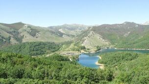
Cervera de Pisuerga, Cantabrian Mountains
|
Exposures: Not too good.
Year Mapped: 2002 Accommodation: Fuentes Carrionas Camping, cost about £2 per day. Food: Supermarkets about 1km away. |
|
Transport: Travelled to, within area and to shops on foot.
Weather: Mostly Sunny During August, less so during September, rained for about 5 days in Storms and Heavy Rain, no wind or snow, Temperatures from 5 - 25 C.
Total cost: about £500 : £180 travel; £100 accommodation; £180 food.
Weather: Mostly Sunny During August, less so during September, rained for about 5 days in Storms and Heavy Rain, no wind or snow, Temperatures from 5 - 25 C.
Total cost: about £500 : £180 travel; £100 accommodation; £180 food.
|
Year Mapped: 1999
Accommodation: Campsite in Ruerga cost about £2 per day. Food: Cervera about 3km away Transport: Used a car for getting to area, travelling within area and to go to the shops. Weather: Sunny everyday, rained for 4/5 days, occaisional light breeze, no snow or ice, temperatures in excess of 35 C Total cost: £450 : £300 travel; £60 accommodation; £60 food. Vertical Divider
|
Year Mapped: 1997
Accommodation: Campsite in Ruerga cost about £2 per day. Food: Cervera about 3km away Transport: Used a car for getting to area and to go to the shops, travelled within area on bike and foot. Weather: Sunny everyday, rained for 3 days, but storms frequent at night, occasional light breeze, 2 hailstorms, temperatures on average about 30 C Total cost: £1100 : £700 travel; £35 accommodation; £350 food. |
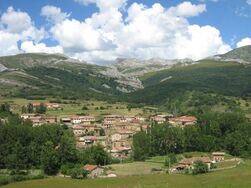
Celada de Roblecedo, Cantabrian Mountains
|
Exposures: Not Good.
Accommodation: Olmares Apartments cost £100 per week. Food: Supermarkets about 15km away Transport: Car to the area (from Bilbao) and to shops, travelled within area on foot. |
|
Weather: Sunny everyday, rained for 15 minutes, refreshing breeze on top of mountains, no snow or ice, temperatures about 12 - 43 C
Total cost: about £ 800 : £270 travel; £500 accommodation; food £?.
Year Mapped: 2001
Total cost: about £ 800 : £270 travel; £500 accommodation; food £?.
Year Mapped: 2001
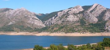
Los Barrios De Luna, Cantabrian MountainsExposures: Very Good. |
|
|
Year Mapped: 2000
Accommodation: Camping Mirantes de Luna cost about £4 per day. Food: Magdalena, nearest town 10 miles away. Transport: Ferry to area, used a car and walked for the shops and travelling within area Weather: 28 days of Sunshine, 5 days of rain, no wind, snow or ice, temperatures about 25 - 32 C. Total cost: about £460: £260 travel; £100 accommodation, £100 food. Vertical Divider
|
Year Mapped: 1992
Accommodation: Hostel in Villacesino cost £12 per day with 2 meals. Food: San Emiliano about 5 miles away. Transport: A car was used to get to the area, around the area and to the shops. Weather: Lots sunshine every day, a storm or two every few weeks, barely any wind, snow and ice unlikely, temperatures about 20 - 28 C. Total cost: about £850: £400 travel; £400 accommodation, £30 food. |
|
Copyright © 2020 Oxford University Geological Society
|
