With the rocks across the Alps and the Massif Central exhibiting evidence of two major orogenic periods, France is great place to do your mapping and has proved very popular with undergraduates in the past! The Alps include some of the highest mountains in Europe and are particularly great to map if you love structure and metamorphic rocks, whilst the country's central core and Southern coast is popular amongst those looking to map more sedimentary rocks (and for a bit of a warmer climate).
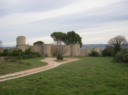
Montegenèvre, French Alps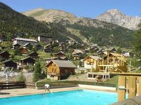
Outline of Geology: Ophiolitic sequence (the Chenaillet Ophiolite, from the closure of the Tethys ocean), and sediments from European margin. Best preserved pillow basalts in Europe (apparently).
Topographic description: Pretty hilly. Montgenèvre village was at ~ 1800m, and the two biggest hills in our area were ~ 2500m. Accommodation: ‘Go Montgenevre’, run by a lovely English couple named James and Julie Hodson. http://www.go-montgenevre.com/contact/ Food: There was an excellent kitchen in our accommodation. James / Julie drove us into Briançon to shop, though they would have lent us a car (if any of us could / wanted to drive). There was a small shop in Montgenevre, but it didn’t sell very much and was expensive, so we only bought our baguettes there. The local bakeries sold beautiful pastries, and we walked into Claviere in Italy for ice-cream. Transport: Flight to Turin, transfer organised through our accommodation. Within walking distance to our mapping area, though we did buy a ski lift pass. Weather: Beautiful. 5/6 weeks were sunshine. Hot, but not too hot once up into the mountain. A few thunderstorms. Total cost: Accommodation was ~ £500 each, flights were ~ £150 each, transfer £60 each, etc Would you recommend this area?: Definitely. Lovely weather and not too hot, and just generally a beautiful place to spend six weeks. Geology was interesting, good range and rock types and structure, so there was plenty to talk about in the write-up. Year Mapped: 2017, 2012 Drac Blanc Valley, Champsaur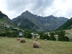
Outline of Geology: South-Eastern edge of Pelvoux crystalline massif, with thrust sequence of cover/basement, including Mesozoic shelf carbonates, nummulitic limestone, lying unconformably on basement, dolomite, spilite and sandstones.
Topographic description: up to 3100m elevation, Valleys and ridges. Exposure excellent. Accommodation: Self Catering apartment cost about £5 per day Food: Supermarkets(40min drive) and small shop about 20m away. Transport: Travelled to area by car, walked within area and used a car to get to the shops. Weather: Sunny except a few thunderstorms, very windy high up, no snow, temperatures about 15 - 30 C. Total cost: about £1200. Year Mapped: 1992 |
La Grand-Combe, Cevennes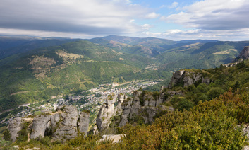
Outline of Geology: A folded set of metamorphic schist and gneiss basement, over which a thick sequence of Carboniferous cyclic conglomerates - sandstones - shales and coals have been deposited. A Triassic Flat-lying unconformable unit then overlies these rocks (marine sediments), the unit is slightly deformed with some normal faults and a poorly exposed thrust sheet.
Topographic description: From 200 - 600m above sea level, semi-mountainous terrain. Heavily forested hills with steep, but accessible slopes. Hardly any flat land. Exposure is fair, but outcrops are small. Accommodation: Gite, Le Pontil cost £7 per day, for 2 weeks, and camping at Font de Merle, cost £3 per day. Food: Local bakery and Supermarket in La Grand-Combe between 1 and 5km away. Transport: Travelled to area by coach to Nimes and Train to La Grand-Combe, walked in area, and occasionally took train or taxi to shops as well. Weather: Sunny, only rained for 1 day. some slight breezes, and no snow. Temperatures up to 40 C. Total cost: £600 : Travel: £230; Accommodation: £200; Food: £150. Year Mapped: 2002 Devoluy, Les Hautes Alpes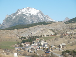
Outline of Geology: Sedimentary cover of external zone of Western Alps, SE France. Late Mesozoic and Tertiary limestones, marls and sandstones. Glacial moraine important as it covers a large proportion of the area.
Topographic description: 1000 - 2000m elevation, hilly terrain. Exposure variable, typically excellent, although some covered with Scree. Accommodation: Local guesthouse, cost about £3.50 per day Food: Bread in village, shopping at Superdevoluy(8km) or Gap(40km). Transport: Travelled to area by car, walked within area and used a car to get to the shops. Weather: Sunny when it wasn't raining, lots of rain, very windy, snowed once, temperatures about 15 - 30 C. Total cost: about £700+: £250+ travel; £150 accommodation, £300+ food. Year Mapped: 1992 |
Clermont l'Herault, Montagne NoireOutline of Geology: Mesozoic sedimentary sequence with basaltic lavas and some palaeozoic sequences, some with localised tectonic contacts.
Topographic description: up to 550m elevation, Hills and valleys. Exposure good. |
|
|
Year Mapped: 1992
Accommodation: Campsite cost about £5 per day Food: Town about 3-4km away. Transport: Travelled to area by plane, walked within area and hitched to the shops. Weather: Lots of sunshine with little rain or wind and no snow. Temperatures about 16 - 27 C. Total cost: about £300: Travel:£150; Accommodation:£160 Vertical Divider
|
Year Mapped: 2002
Accommodation: Campsite cost about £4 per day and Rented House cost about £8 per day. Food: Supermarket about 20 minutes drive in Clermont. Transport: All Travel By Car. Weather: Lots of sunshine with little rain (except for evenings or overnight) some strong wind and no snow. Temperatures about 20 - 30 C. Total cost: about £470: Travel:£170; Accommodation:£200; Food £100. |
Crozon Peninsular, Cameret-sur-Mer, Brittany
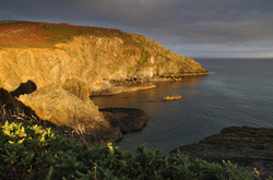
Outline of Geology: Folded sediments of Precambrian - Devonian age.
Topographic description: 0 - 60m elevation, flat with a few hills. Exposure excellent on coastline, much poorer inland..
Accommodation: Farm cottage (1.5hrs away by car). £20 per day.
Food: Supermarket (2 miles away).
Transport: Travelled to area by ferry/car, used car within area and to the shops.
Weather: 50:50 sunshine and rain. Breezy with no snow. Temperatures about 14 - 25 C.
Total cost: about £800: Travel:£300; Accommodation: £300; Food: £200.
Year Mapped: 2001
Saint-Chinian, Occitanie, South West France
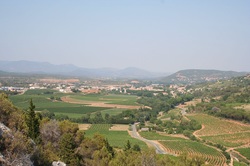
Outline of Geology: Tertiary and Mesozoic limestones with a few fossils: forams, oncolites and laminae. Associated marls. Ordovician Schists thrusting into a stack.
Topographic description: 150 - 300m elevation, gentle slopes and steep scarps. Exposure good.
Years Mapped: 1998, 2000, 2003
Topographic description: 150 - 300m elevation, gentle slopes and steep scarps. Exposure good.
Years Mapped: 1998, 2000, 2003
|
Year Mapped: 1998
Accommodation: Campsite cost about £4 per day Food: Bezier Auchan (20km away) and local shops about 500m. Transport: Travelled to area by car, walked and used car within area and to the shops. Weather: Lots of sunshine with rain once a week, wind was breezy and no snow. Temperatures about 20 - 39 C. Total cost: about £300: Travel:£300; Accommodation:£150; Food: £200. Vertical Divider
|
Year Mapped: 2000
Accommodation: Rented house in Saint-Chinian, £350 for 5 weeks. Food: Ecomarche. 5mins by car. Transport: Travelled to area by plane, train and car, used a hire car within the area and for the shops. Weather: Lots of sunshine with a weekly storm, could get quite blustery. Temperatures about 30 - 40 C. Total cost: about £1000: Travel: £430; Accommodation: £250; Food: £250, Insurance: £60 |
|
Copyright © 2020 Oxford University Geological Society
|
